Distance

The single-track trail begins to climb immediately and within 10 minutes produces a spectacular view of Shuswap Lake. Another five minutes later there is a minor junction where a side trail diverts to a viewpoint. The main trail resumes to the right (straight).
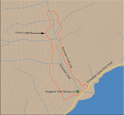
Through thick forest, the way takes you creekside amid spruce and pine, with the rumble of Margaret Falls as a constant in the background. A half-hour into the hike the trail comes to its first key intersection. At this point you have trekked 1.4 km from the wooden staircase off Sunnybrae Canoe Point Rd. The sign says the west portion of Upper Canyon Loop carries on straight and the Lower East Reinecker Creek Trail goes up a narrow trail to the right. Although the sign back at the parking lot gave the distance to Lower East Reinecker Creek Trail as 4.3 km, the one at this junction claims it is 4 km. Regardless, clamber up the right fork of this junction.
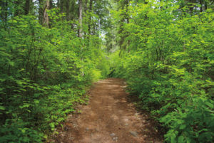
For the next hour, the trail presents no obstacles; it does nothing other than ramble through an ever-changing forest of cedar, spruce, hemlock, alder and birch. But it’s an enchanting forest and thus a totally enjoyable interval. The hour is interrupted by a minor bridge crossing over an insignificant stream after the trail descends briefly.
The path climbs just as briefly for about five minutes before passing through a wooden gate. Five minutes beyond the gate, the Upper East Reinecker Trail ends and you have the choice of taking South Crossing Trail to the left or Upper East Reinecker Trail to the right. Go left. As the marker indicates, the South Crossing Trail is 1.2 km long. On this post, trail distances have been corrected with ink – more unnecessary confusion.
You will cross Reinecker Creek in another few minutes, putting you on the west side of the creek with almost a kilometre behind you from the previous bridge. The next 15 minutes (about 1 km) is a mixture of an undulating trail through forest, over boardwalks and alongside cutblocks.
Some 1.2 km from the last junction, the trail is split, with a marker directing you leftward down the Lower West Trail. You have now joined a multi-purpose decommissioned logging road that was in good use on my last trek along it. This trail ends, and so does your journey, in 4.5 km.
The next couple of kilometres are relatively uneventful until the forest opens up and you find yourself in the middle of an active logging zone. This is really quite fascinating, and as it is such a vital segment of the BC economy, there is a certain amount of awe when walking through one of hundreds of such zones throughout the province. So much machinery, manpower and planning, and the impact on jobs is evident in cutblocks such as this. The Shuswap Trail Alliance has done a superb job of updating the posts with directional arrows in the midst of this dynamic, ever-changing logging landscape. In the spring of 2012 two such posts guided you safely within this area. This may change as the terrain is altered. At most, you should be through this landing within 10–15 minutes.
Signage will drop you down to the left, back onto the main path, and once again your feet pound a trail of gentle, silent earth. After 10 minutes of strolling back through a forest, you find the first of five unmistakable signs placing you safely on Sunnybrae Canoe Point Rd.
Turn left on the pavement to regain the parking lot within a few short minutes.
Directions
From downtown Salmon Arm, travel west on the Trans-Canada Highway for 15 km and turn right onto Sunnybrae Canoe Point Rd. Drive 11.2 km to arrive at the Margaret Falls parking lot, on the left side of the road.