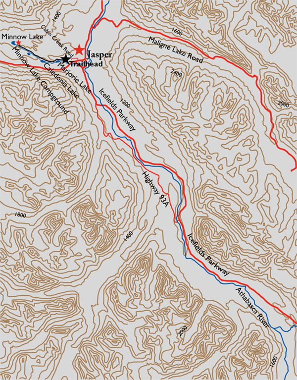
Distance

After 2.5 km of effortless strolling from the trailhead, through open woodland, the trail arrives at Marjorie Lake and runs alongside the length of it. The forest here is reminiscent of a British Columbia Interior forest. This spectacularly clear mountain lake is backdropped by Indian Ridge and Muhigan Mountain, with the latter situated more to the northwest. Two more kilometres beyond here, Caledonia Lake appears through the trees. This lake is considerably larger than Marjorie Lake, at almost 750 m in length. The trail ascends and parallels the eastern shoreline, producing an exceptional downhill view for the length of the lake.
Beyond Caledonia Lake, the trail follows a connector stream and heads into the forest for 20–25 minutes until reaching Small Lake to the left, with a limestone ridge looming over the trail high up on the right.
Fifteen to twenty minutes past Small Lake, and 9.5 km from the trailhead, is the junction to Minnow Lake Campground. Stay left and 800 m of easy going will take you to Minnow Lake Campground. Continuing up to the right for 4 km will bring you to High Lakes Campground, but it pales in comparison to Minnow Lake. This 4-km distance gains 155 m in elevation and is really not worth the effort considering the impressive views bestowed by Minnow Lake.
History
As the exploration and mapping of the Rocky Mountain Parks gave way to tourism development, the Jasper area fell significantly behind the southern regions of Banff and Lake Louise. Most of the responsibility for expanding the trail network and access to the backcountry was shifted to the park wardens. They took over the construction, preservation and overall operation of the trails. An example of these duties was demonstrated by Warden J.A. Rootes’s blazing of a rough path from the town of Jasper to Caledonia Lake in 1913. This was done to promote fishing in the area and was the first recorded exploration into this part of Jasper.
The following year, a Dominion land surveyor, Hugh Matheson, may or may not have discovered Marjorie Lake. Historical information about this trail is sketchy, so it is uncertain whether the original trail cut by Rootes had missed Marjorie Lake. It is also unclear why Matheson gave the lake the name, as apparently, there is no known connection between him and a Marjorie.
Directions
From the intersection of Highway 16 and the Icefields Parkway, drive into the township of Jasper. Immediately, the Icefields Parkway becomes Connaught Drive. From the traffic light, drive 1.8 km on Connaught, turn left onto Miette Avenue and go 700 m to the end of Miette Avenue. Turning left here will put you on Pyramid Lake Road, which quickly becomes Cabin Creek Drive behind a mobile home park for 700 m. On the right side of Cabin Creek Drive, across the street from the second of two signs marked “Poplar Avenue,” is a short gravel road. A gate at the end says “Water Supply. No Trespassing.” Park here. The trailhead is on the left, down the embankment.