Distance

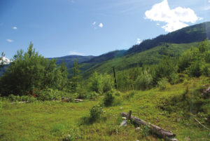
The now single-track path gently undulates as it follows a slope.
After the first kilometre (15 minutes), the path comes close to the canyon edge, and the cliffs of the other side of the canyon become visible. These cliffs are your ultimate destination.
Five minutes later the trail drops slightly to cross one of the narrow tributaries of Attenborough Creek. Then two more small creeks are crossed in succession within 5–7 minutes.
One-half hour, or about 2 km, into the hike the trail presents magnificent, though brief, views down the canyon.
For the next 20 minutes, the trail alternates between steep climbs and plateaus until it presents a stunning viewpoint. You have hiked approximately 3 km.
For almost 2 km beyond this, the path climbs off and on as it delivers occasional panoramas of the canyon and surrounding mountains, but nothing is as fulfilling as reaching the impressive summit of the canyon rim.
There are a couple of false summits as you climb, and even when the maximum elevation is gained, there is still more to see with another 10 minutes of level walking beyond the summit. This additional 10 minutes provides tremendous rewards.
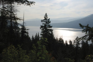
Terrace Mountain is the standout, 5.6 km due south. Glimpses of Okanagan Lake can be seen to the southeast (left) and Shorts Creek Canyon is directly beneath you. Making this trek gifts you with an immense day. This is truly one of the best hikes in the North Okanagan.
Directions
From Vernon, drive north on Highway 97, and at the north end of Swan Lake continue on Highway 97, following the signs for Kamloops. Travel 5.6 km, driving past the Spallumcheen golf course and Historic O’Keefe Ranch, and highway signs will direct you down Westside Rd. toward Fintry and Killiney. Travel along Westside Rd. for 18 km to Beau Park Rd. on your right.
Reset your odometer; there are kilometre markers along this gravel road, but do not confuse them with the distances you will travel to arrive at the destination. The course is obvious, but there are a few turns that will require minor detailed descriptions.
At the 2.5 km point, stay left, leaving Beau Park Rd. and joining Bouleau Lake Rd. At 4.6 and 7.6 km, veer left again, now joining Whiteman Creek Rd. Veer left again at 8.3 km. Turn left at 9.9 km, leaving the main branch of Whiteman Creek Rd., immediately crossing a short bridge. A green arrow pointing to the left is another indicator of where this left diversion must be made. The gravel road begins to climb.
At 15.5 km, make sure you follow the road on the right. There is an arrow marker here as well. Then, 200 m on, take the left fork, where a HIKING TRAIL sign is posted. At 16.9 km, stay to your left, and another 500 m farther will bring you to the trailhead, where there is an old logging landing to park on.