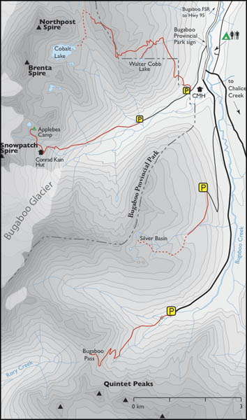
Distance
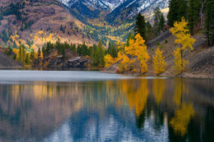
From the lofty meadows by the highest of the Silver Basin tarns, gaze out at the Quintet Peaks, Sextet Ridge, Septet Range, Chalice Ridge and the summits by Bugaboo Pass. The midday colours with pastel glaciers, the reflective tarns and the wildflowers are what really motivate us to keep coming back. The damp meadows sway with stems of purple asters, paintbrush and many other species. When the flowers are at their best, so are the many species of biting bugs.
A short climb from the highest tarn leads to the ridge where you can see a close-up view of Snowpatch Spire.
As with other Bugaboo area hikes, the helicopter traffic is audibly evident. Fly-overs and heli-hikers may visit this basin a couple times a day in summer. However, I have not found them interfering with our enjoyment of the region. Silver Basin remains a place of calm, contrasting the busy and dramatic energy of the rest of the Bugaboos.

0 km: From the second switchback at the end of the road, hike up a worn trail on the deactivated portion of the road.
1 km: Approach a creek but do not cross it. About 20 m before the creek, look uphill to the right (southwest) into the forest for flagging or a trail.
1.3 km: Follow the intermittent trail uphill across wet spots in the forest for 300 m to a fallen log bridge, N18313-E20639. Once across the creek, you will see only fragments of a trail. Crash your way up the debris of a clear-cut and angle left (southwest) away from the creek for a couple hundred metres. Ascend in the forest by damp creeks at the edge of the clear-cut.
2.4 km: The first meadow, N17733-E20067. From here the area is open and you can wander in high-country meadows of flowers and creeks and see at least two tarns.
3.8 km: Highest tarn, N18308-E19278. Above the tarn, hike up 120 m (400 ft.) on the rocks to reach the pass and see the Bugaboo Spires.
Directions
Main Bugaboo FS road; any vehicle; open late spring to fall; potholes, washboards, dusty; Silver Basin Road is 4x4 high-clearance for final several kilometres overgrown with alders.

Janice Strong
Janice Strong is an established professional outdoor photographer. Her images grace collections all over the world and appear in many respected publications. She is passionate about hiking and is also an avid snowshoer and skier, exploring the outdoors of the East Kootenay in southeastern BC year round.She openly shares her passion for the outdoors with others and has introduced hundreds of people to the joys of hiking. For a decade she led hikes for the City of Cranbrook – Parks and Recreation. With her guidance, many people have themselves become enthusiastic hikers.
Climbing mountains, finding new places and enjoying the experience of the journey have always been important to Janice. She cherishes the little things she sees along the trail, as well as the grand destinations.
When Janice is not writing, hiking or taking photographs, she is involved in various creative digital, website design or photographic projects for her clients. She and her husband, Jamie Levine, enjoy their rural property, near Cranbrook, BC.