Distance
A well-travelled trail winds along the eastern shores of these scenic, long, narrow, lowland lakes. The trail crosses exposed bedrock and lakeside talus slopes and winds through the forest. After the initial 500 m up a steep section, the rest of the hike is easy and mostly level. But there is about a kilometre of level, but lichen-coated, talus to walk on, and it is very slippery when wet.
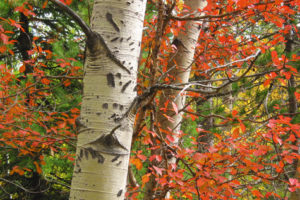
In springtime (early May to early June) the lakeside meadows are awash in the glorious colours of wildflowers, bees and butterflies. Clematis vines climb up rose bushes and fairy slippers hide in the darker shadows of the woods. Mid-September to early October is when the aspens around the lakes are ablaze in yellow.
Further exploration
Silver Spring rim overlook
Imagine standing atop the cliffs overlooking the three Silver Spring Lakes and the Rockies to the north. The Silver Spring rim overlook is just the hike to accomplish this.

0 km: From the parking spot, hike west (back toward the bridge) on the main road for about 150 m to the well-worn footpath. Climb the trail to intersect with the power line.
100 m: Cross the power line and hike south, up a steep small trail beside the washed-out gravel road. The entire steep section takes about 20–30 minutes and gains 100 m (300 ft.) to the northern shore of the first scenic lake.
600 m: At the shore of the first lake, turn left (east) and hike up a short, steep, rocky section. Follow the trail south as it winds along the bedrock banks. The main trail edges the base of the prominent bedrock platforms, but a 1-minute hike upward to the right offers a breathtaking view of the navy-blue first Silver Spring Lake, rimmed with cliffs, N62219-E40106. Many visitors stop there, as it one of the highlights of the whole trail. Continue along the eastern side of the first lake and the trail heads into the forest.
2.4 km: Second lake. Between the second and third lakes, cross a level section of talus that may be slippery. The trail winds in sections of forest and talus. Gain very little elevation.
3.7 km: Third lake. The best viewpoint for the third lake is on a low rock platform near its north end, N60027-E39941, another highlight of the trip. Navy-blue water flows below cliffs that rise hundreds of feet straight up. If you reach the eastern shore of the third lake, backtrack a bit and find a faint trail heading west into the forest by the shore. This will lead you to a well-used picnic area and a bedrock platform a couple of metres above the water with a great view of the cliffs and clear lake.
Directions
Road: any vehicle; mostly pavement
0 km: Turn east from Highway 3 in to Elko, N62200-E37100. The Elko townsite is not visible from the highway. The turnoff is south (slightly downhill) from the prominent gas station/restaurant along Highway 3. The paved Bate Avenue in Elko winds through town around several corners. Stick to the main road.
1.1 km: Turn sharp left (east) and head downhill 400 m to cross the Elk River. Drive the industrial gravel Elko/Morrissey haul road 2.3 km east from the bridge. The river bends away from the road for a couple of kilometres.
3.8 km: Notice when the river flows close to the road again and drive another 200 m. Turn left at the first left fork past the bridge onto a small dirt road, N62791-E39791, and park. From the parking spot, hike back along the main road for about 150 m and look for a well-worn footpath heading uphill in the forest (south). The trailhead is unsigned.

Janice Strong
Janice Strong is an established professional outdoor photographer. Her images grace collections all over the world and appear in many respected publications. She is passionate about hiking and is also an avid snowshoer and skier, exploring the outdoors of the East Kootenay in southeastern BC year round.She openly shares her passion for the outdoors with others and has introduced hundreds of people to the joys of hiking. For a decade she led hikes for the City of Cranbrook – Parks and Recreation. With her guidance, many people have themselves become enthusiastic hikers.
Climbing mountains, finding new places and enjoying the experience of the journey have always been important to Janice. She cherishes the little things she sees along the trail, as well as the grand destinations.
When Janice is not writing, hiking or taking photographs, she is involved in various creative digital, website design or photographic projects for her clients. She and her husband, Jamie Levine, enjoy their rural property, near Cranbrook, BC.