Distance
The shelter is first-come, first-served, and overflow camping is on non-designated pads in the meadow beside the shelter. Because of this system, it is advisable to bring a tent and not depend on the availability of the shelter. The metal bear boxes outside the shelter are to be used by tenters too, not just by shelter occupants. More details are at www.env.gov.bc.ca/bcparks/explore/parkpgs/mt_assiniboine.

You’ll see a marker sign, the first of many to come, within the first couple of minutes. The straight line will take you down the Mount Shanks Trail, with a marked distance of 6.9 km. This same sign will direct you to make a 90° right turn to the desired Simpson River Trail. The sign is a tad confusing, as it states that it is 8.6 km to the “SIMPSON RIVER TRAIL,” when 8.6 km is actually the distance to the boundary of Kootenay National Park and Mount Assiniboine Provincial Park. The Surprise Creek shelter and campground are in fact 10.6 km away.
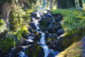
During the next 15 to 20 minutes you’ll cross numerous minor streams with an easy stride on a path that remains flat and open. For almost 2 km of enjoyable, wide open vistas, the trail and the Simpson River almost touch. The route then rises momentarily above the river, only to succumb to the river’s trance once more to parallel it for another ten minutes before climbing above it again.
With the river meandering below for the next half-hour or so, its proximity varies but it is always within earshot. Up here, as you venture farther into the backcountry, the already narrow path becomes even slimmer, though it widens temporarily at a major creek crossing an hour and a half into the journey. The log bridge at this crossing permits views even more spectacular. From the openness of the stream crossing, the hike moves away from the Simpson River and continues to wander up high for another 20 minutes until gently, almost unnoticeably, dropping back down to the river.
Gradually, the trail brings the river closer and parallels it for an additional 20 minutes. As it does this, the route becomes trapped in the incredibly damaged forest, with a high escarpment flanking its left and the Simpson River on its right. This makes for an interesting, narrow, flat flood plain with no escape during flood season, and the terrain through these lowlands can be boggy even in mid-summer. Slowly the trail begins to climb until it eventually settles high above the Simpson River.
Within 10 or 15 minutes, once you’re up on the plateau, the river becomes distant and unheard. The scorched forest transitions into a beautiful, lush Rocky Mountain landscape of mature spruce and pine, and you come to the first of many boardwalks. Continue up here through gorgeous forest along many boardwalks over moist ground until you reach the boundary between Mount Assiniboine Provincial Park and Kootenay National Park. The landmark itself presents with minimal fanfare – just a simple mileage post marking the line. However, there is a swath cut straight through the forest as far as you can see. It seems that the boundary required marking by removing a 10-metre-wide strip of forest.
Two easy kilometres remain to be explored before you reach the Surprise Creek shelter and campground. Not much changes, as the river continues to follow the path but remains far below. The main change along the route now is that the forest becomes significantly richer as mosses and ferns dominate the understorey, necessitating the construction of many more boardwalks. Thirty minutes of intermittent boardwalking finally brings the trail back down to the Simpson River. The shelter and campground are reached by crossing a secure, lengthy suspension bridge over the river.
This tranquil setting is unique. On a cloudless evening, the uncluttered, exposed meadow beside the cabin is a far cry finer than spending the night in the cabin’s dark, dingy interior.
The closest day hike is a 9-km jaunt to Rock Lake that entails a moderate elevation gain of 608 m. The route is clearly marked at the Surprise Creek area and the path has no obstacles. This is simply a steady uphill climb to the trail and lake.
Simpson River Trail history
James Hector gave the name Simpson to a river, a pass, a ridge and a mountain in honour of the governor of the Hudson’s Bay Company, Sir George Simpson. In 1841 Simpson visited the region that later, in 1920, would become Kootenay National Park. He was the first white man on record to visit the area and did so while on a more monumental adventure of attempting to circumnavigate the planet in record time. He followed the Simpson River to its meeting with the Vermilion, travelled down the Kootenay River and crossed through what is now Sinclair Pass, finally ending up at the Columbia River. Needless to say, Simpson did not linger here for long, although he surely loved the scenery.
Hector took time to stop and smell the flowers, though, particularly a wildflower called Bryanthus empetriformis. At the summit of Simpson Pass, he discovered this species of pink flowering heath which he compared to “… the very heather of the Highlands of Scotland.” Another discovery, maybe not quite so pleasant or beautiful, was his run-in with deerflies as quoted in Brink and Bown’s book Forgotten Highways:
We made another discovery, about which there can be no mistake, in a troublesome and venomous species of winged insect, which in size and appearance might have been taken for a cross between the bull-dog and the house fly.
James Hector led an offshoot of the Palliser Expedition into the north end of Kootenay Park in 1858 with the hope of discovering the source of the Bow River and a possible pass as a trading route to the Columbia. It was during this journey that he gave the name Simpson Pass to honour the man who was the first European to visit both this area and present-day Banff. It was on this same trip that Hector was kicked in the chest by an ornery horse and was left for dead. Through an extraordinary recovery, he was able to continue his travels for many more years. A river in the region of the incident was hence named the Kicking Horse River.
George Simpson was born in 1786 or 1787 in Lochbroom, Scotland, and was raised by his father’s sister, Mary Simpson. Simpson achieved tremendous business administration experience at a young age when he found employment in London with a company of sugar brokers. With only limited education, and no experience in the fur trade, he achieved overwhelming success. Through perseverance, hard work, an unparalleled hardiness in the wilderness and a few lucky breaks, Simpson eventually became governor of the Hudson’s Bay Company, making him one of the most powerful men in British North America at that time.
Mount Assiniboine history
This beautiful peak was named in 1885 by Dr. G.M. Dawson, for the Native people of the area. This was a bit of a faux pas by Dawson, however, since the Assiniboine people were not the region’s permanent residents but only hunted in this peaceful part of the Ktunaxa (Kootenay) Indians’ territory.
Two years before, Tom Wilson had led Chicago businessman Robert L. Barrett to the base of the mountain by way of Healy Creek, Simpson Pass, Ferro Pass and finally down into the Mitchell River Valley.
George M. Dawson, a geologist, anthropologist, author, teacher, civil servant, geographer and paleontologist was born in Nova Scotia and schooled at McGill (then college) in Montreal, the Royal School of Mines in London and the Geological Survey of Great Britain. While Dawson was teaching chemistry at Morrin College in Quebec City in 1872, a position opened with the Geological Survey of Canada and he obtained it. He first came to the Rockies in 1884 as leader of a team assembled by the British Association for the Advancement of Science.
In the summer of 1901, James Outram and his climbing companions Christian Bohren and Christian Hasler became the first party to climb to the summit of Mount Assiniboine. The first solo ascent was made by Lawrence Grassie in 1925.
Directions
The large highway sign marking the Simpson River Trail is 46.8 km down the Banff–Windermere Highway (Hwy. 93) from Castle Junction and 6 km south of Vermilion Crossing. The gravel pullover is on the east (left) side of the parkway, with minimal parking. The pleasant setting of Vermilion Crossing contains the Kootenay Park Lodge, Kootenay Park Visitor Centre and a day-use picnic area.


Gerry Shea
“Gerry Shea moved to Kamloops from Vancouver at the age of nine, which is when he became enchanted by the nearby hills. It was on a family vacation many years later that he discovered the mountains and began hiking and climbing in his spare time, gathering knowledge and experience that he has since used to help beginning hikers, scramblers and backpackers to trek safely. Gerry lives in Kamloops with his wife and children.”Excerpt From: Gerry Shea. “The Aspiring Hiker’s Guide 2: Mountain Treks in British Columbia.” iBooks.