Distance

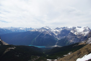
Five to six minutes of walking this magnificent forest sees it open up into an equally magnificent valley. This is fantastic. The long walk through this area gives unparalleled views of Mount Sir Donald, Terminal Peak and Uto Peak to the east and Lookout Mountain straight ahead to the south. For 30 to 40 minutes, the trail darts in and out of sections of forest of varying length, but for the most part the path sorts its way upward in the wide open Illecillewaet Valley.
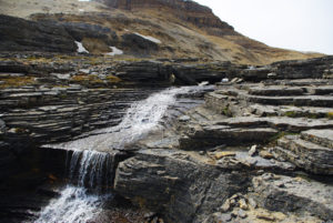
Mingling with the sweat of your efforts as the hike begins to ascend is spray from the torrent of meltwater tumbling to the rocks below. The Vaux Glacier releases its payload at such an incredible rate that it is difficult to comprehend the amount of ice and snow that must be present in one spot to sustain such a massive flow of water. As you approach the first of two aluminum bridges, the trail dips down into a gorge that puts you just a few feet above a violently churning yet somehow calming Vaux Creek. Stand a moment and feel the spray on your face. Such a lot of water.
Switchbacks become steeper after the second bridge despite the spacious, flat, uniform appearance of this wonderful valley. As the route ascends, the scenery improves, and the site of mountain peaks, glaciers, tarns, streams and waterfalls should satisfy all of your fantasies of natural beauty. Look closely for scrapings on the limestone tables left behind by receding glaciers. About 15 to 20 minutes farther upward, the trail reaches a clearly marked fork. Sir Donald Trail carries on to the left, the Perley Rock route to the right.
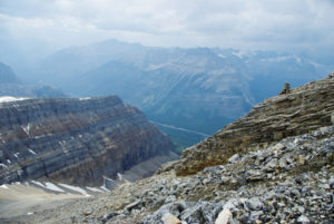
Watch your step along here, as the path takes off along the bottom of a wide gully and loose rocks can easily roll even the strongest ankles. More beauty is revealed to you as a reward for climbing higher. Almost as rewarding is an enjoyably level patch of ground to rest before the final push. The trek now finishes with a quick spurt of 153 m of elevation gain, partially along the Vaux Glacier moraine, to the top of a wide open basin. Above you to the northeast looms the unmistakable tower of Mount Sir Donald, with the Vaux Glacier in the foreground.
The col you will land on is used as a base camp for climbing the spectacular Mount Sir Donald. To the southwest, 9.5 km away, stands Mount Bonney. The Illecillewaet Glacier is to the south and Uto Peak is directly north.
Mount Sir Donald history
On November 7, 1885, the last railway spike linking the east and the west ends of the Canadian Pacific Railway was driven into the ground at Craigellachie, BC, by a director of the CPR, Sir Donald Alexander Smith. The ceremony was small and brief compared with other such commemorative events, and there was very little fanfare. Had the Governor General, Lord Lansdowne, been able to attend as initially planned, the event might have been more of a spectacle, but he was required to return to Ottawa just before the ceremony, despite having made the long trip out West for the event. Lord Lansdowne had even had a silver spike manufactured to commemorate the moment, a distinctive touch compared to the gold spike that completed the first Us transcontinental route with the connection of the Central Pacific and Union Pacific railroads in 1869. As it turned out, though, the silver spike was unavailable, so William Van Horne declared, “The last spike will be just as good an iron one as there is between Montreal and Vancouver…”
It is that same Sir Donald Alexander Smith that Mount Sir Donald was named for by way of a federal order-in-council, meaning the name was decided by Cabinet and then officially endorsed by the Governor General. In addition to being a director of the CPR, Smith was a Hudson’s Bay Co. officer as well as a politician, diplomat and philanthropist. The mountain had originally been named “Syndicate Peak” as a tribute to all the principal financiers of the CPR.
Although it was named in 1885, the mountain was not climbed until five years later, by Emil Huber, Carl Sulzer and their porter, Harry Cooper. Huber and Sulzer, both amateur Swiss mountaineers, arrived at Glacier House on July 21, 1890, with the ambition of nothing short of summiting Mount Sir Donald during that climbing season. The allure of Mount Sir Donald was twofold: it was, and still is, technically challenging; and it has a distinctive Matterhorn-like shape. The party completed their goal just five days after their arrival, ascending Mount Sir Donald via the southwest wall on July 26.
The pair had climbed to the top of nearby Uto Peak on July 23 to gain a vantage of Sir Donald, and it was there that they devised what appeared to be the easiest way to the summit of Mount Sir Donald. Their course from Uto Peak to Mount Sir Donald across the edge of the Vaux Glacier is the most noted route still taken today.
Directions
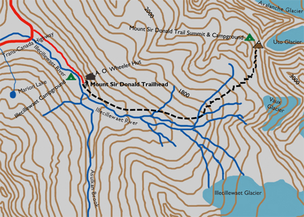
The trailhead is located in the Illecillewaet Campground recreation area, 3 km west of the summit of Rogers Pass. This minor exit off the highway is a busy little mecca for campers, hikers, scramblers, climbers, cross-country skiers and picnickers. Enter the campground off the east side of the Trans-Canada Highway, drive past the day-use area and park in the lot just past the small welcome centre, where you can purchase passes for camping or day hiking. The well-marked trailhead lies just beyond the welcome centre. In fact, all of the routes in this vicinity are identified by an abundance of bulletin boards, maps and markers. From the welcome centre, walk up the road as it turns to gravel, and the sign to the trailhead will appear in front of you. The A.O. Wheeler Alpine Club of Canada hut is nestled among the trees to your left.
A quick right turn down to the eastern bank of the Illecillewaet River initiates the trek to the summit of the Sir Donald Trail. The leisurely stroll is highlighted by the different textures of green within the protection of the forest. The path is wide and well travelled for the most part, permitting easy gazing at the surrounding ferns and mosses that dominate the thick underbelly of the spruce, hemlock and cedars.

Gerry Shea
“Gerry Shea moved to Kamloops from Vancouver at the age of nine, which is when he became enchanted by the nearby hills. It was on a family vacation many years later that he discovered the mountains and began hiking and climbing in his spare time, gathering knowledge and experience that he has since used to help beginning hikers, scramblers and backpackers to trek safely. Gerry lives in Kamloops with his wife and children.”Excerpt From: Gerry Shea. “The Aspiring Hiker’s Guide 2: Mountain Treks in British Columbia.” iBooks.