Distance

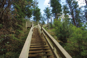
Continue to follow the red EQ 4 markers, which are fastened to trees, as the path makes its way upward. The climbing has begun. A couple of minor trails intersect with EQ 4, but when these approach, don’t deviate from the main path; the way is obvious.
About 2 km, or 30 minutes, into the hike, the forest opens, allowing the hills you are climbing to come into view. Around the same time, the path reaches a four-way intersection. Continue a straight course, ignoring the trails that approach from the left and the right.
EQ 4 now becomes EQ 16. A red marker attached to a tree on the right side of the path will confirm this for you. A few minutes on EQ 16 brings you to a young forest and a sign indicating that this youth was planted in 2000. The trail ascends steadily on a mild gradient.
Ten minutes of steady upward motion delivers you to a magnificent, wide-open, level clearing surrounded by mature birch trees.
Once the trail emerges from the birch-lined clearing it resumes its relentless upward journey to its high destination.
Slightly more than 15 minutes farther on, the path meets a key junction. Trail EQ 22 arrives from the left and cuts across the top of EQ 16, ending its journey. At this T intersection, large arrows guide you out of the trail system, giving you the choice of either right or left. Turn left onto EQ 22 and continue to climb this slow, steady slope. You have now hiked approximately 3.5–4 km. Just so you know what you’re in for, the seemingly endless elevation gain continues for almost another hour, relieved by only a couple of brief plateaus.
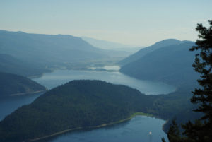
Roughly 1 km after you join EQ 22, the tree line breaks and the panoramas up and down the Skimikin Valley are revealed. As you look to the far left (northeast), Shuswap Lake and Notch Hill dominate the view, but the most visible landmark is Skimikin Lake directly below you.
You will still continue to climb for another half-hour or so, and just before the path finally flattens, a small sign reminds you that you are still on EQ 22. Where the trail levels, trail EQ 34 approaches from the right. EQ 22 comes to an end as it merges into EQ 34.
You have now clambered up 527 m of elevation gain. Congratulations! The trail flattens for a short distance before it begins its drop back down to Skimikin Rd.
Within 10 minutes of downhill hiking, you’ll come to a significant gravel road. Turn left onto it. You are now about 7.5 km, or two hours, into the hike.
Five to ten minutes down the gravel road, a PRIVATE PROPERTY sign is highly visible. It is okay to stay on the road, but do not wander onto the property. Viewing at this point is exceptional as you amble down a superb, vast, open slope.
Slightly more than a kilometre down the gravel road, a well-marked junction with trail EQ 30 sends you off the road and into the forest to the right, where you immediately cross a stream. This is an important crossroad, because the gravel road continues down to private property. This diversion around private property is the reason why there is a 4 km hike back to the parking lot on Skimikin Rd.
About eight to ten minutes on EQ 30, you’ll come to a small clearing that has an unmarked trail on your left. Take this unmarked trail to where it joins with EQ 28 just a few minutes farther along. Turn left on EQ 28.
The next kilometre is a walk on an overgrown double-track road that weaves in and out of forest and meadow. The trail will eventually come to a locked fence, on the other side of which is the same stream that you crossed 45 minutes ago.
From here, the trail becomes EQ 24 and it will take you down to Skimikin Rd. in about 20 minutes.
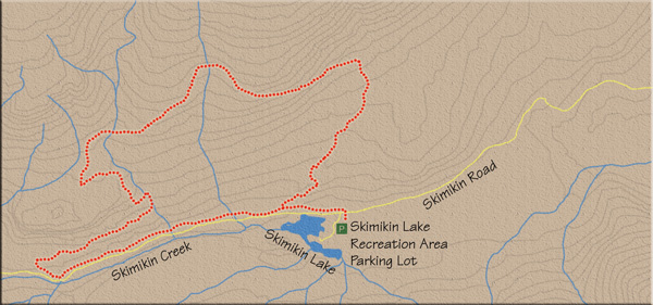
Turn left on Skimikin Rd. and enjoy a 4 km hike back to the parking lot. The landscape on the right side of the road is fed with the slow, even stagnant waters of Skimikin Creek. Patches of marsh and wetland are prevalent where the running water has pooled.
Directions
About 14 km west of Salmon Arm, on the Trans-Canada Highway, turn left (south) onto Tappen Valley Rd. Drive 4 km and turn left on Skimikin Rd. Travel 6 km along Skimikin Rd. to find the Skimikin Lake Recreation area off the left side of the road. The way from the highway is clearly marked with signage. Immediately upon arriving in the recreation area, you will find yourself in a large unpaved parking area. Park here.