Distance

The trail climbs steadily above treeline over a vast subalpine meadow dotted with small firs, crossing small valleys and streams. There are many water crossings, mostly bridged, though a couple of them require rock hopping. One in particular declines sharply into a lovely shallow valley with a troublesome deep stream requiring some minor route finding. The elevation gain from treeline to Little Shovel Pass is only 39 m, so the overall change is not really noticeable, especially since the scenery distracts you from any minor differences underfoot.
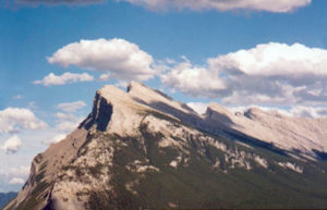
From Little Shovel Pass to Snowbowl Campground the trail drops 144 m of elevation to 2086 m above sea level. The descent is gradual and again not terribly noticeable. Views along the trail up here include the Queen Elizabeth Range to the east and Antler Mountain to the northwest. Mount Hardisty (2716 m), a peak of the Maligne Range, is situated to the southwest. Snowbowl Campground is 12.2 km from the trailhead, nestled in a cluster of trees slightly off the trail. This is a primitive campground with rough tent pads and an open (no walls or roof), elevated outhouse.
There is still 32 km of hiking to complete the Skyline Trail, so a day trip will take you as far as you wish to go. Big Shovel Pass is 5.3 km farther and climbs only 245 m from the campground. Curator Lake and Shovel Pass Lodge are 8.2 and 9.8 km from the campground respectively.
History
As you step out of your vehicle and wander down to see, touch, hear, taste or smell Maligne Lake, stop for a moment and thank Mary Schäffer for her tremendous, unwavering passion to reinstate this wondrous lake into the protective folds of Jasper National Park. She stood here where you are now, almost 100 years ago and set out over the pass now known as the Skyline Trail.
In 1911, this entire region of lakes, valleys, streams, meadows and mountains was taken away from the park, reducing the area of Jasper National Park to slightly more than 1,000 square miles from its former 5,000 square miles. Dr. D.D. Dowling of the Geological Survey of Canada asked Mrs. Schäffer to lead a survey expedition to the Maligne Lake region to try to reinstate Maligne into the park. Three years earlier Mary had explored Maligne Lake by raft, having named many surrounding features, thus making her the most reliable person to reach the Maligne from Jasper to document and map such an undertaking. And so began her second adventure to Maligne Lake.
Outfitter Jack Otto and his party were hired to make trail for the pack team and surveyors. The decided route over the Maligne Range was to be much quicker and less strenuous than traversing the wilderness of the Maligne Valley. Upon approaching the crest of the pass they discovered that enough snow lingered in mid-June to block the pass. Otto sent a work party to cut a trail through the snow for the rest of the expedition to follow. The snow was so deep that the men found it easier to carve two shovels from spruce trees and shovel their way through. After accomplishing this enormous undertaking, they left the shovels sticking upright in the snow at the summit of the pass to guide the group over the pass. At first Mary Schäffer mistook the shovels for “the thinnest legged sheep” she had ever seen. After realizing what the sheep really were, she agreed to name the pass Shovel Pass.
With the surveying and exploring behind her she devoted the following year to work with the Grand Trunk Pacific and Canadian Pacific railways to have Maligne Lake incorporated back into the park. The railways wanted the tourists and Mrs. Schäffer wanted the area preserved. On June 24, 1912, all of their wishes were granted, as the boundary of Jasper Park was expanded to once more include Maligne Lake.
Mary Townsend Sharples was born on October 4, 1861, in West Chester, Pennsylvania, near Philadelphia. Her family were wealthy Quakers, and she became very highly educated in the Quaker tradition. It was during a CPR trip from Montreal to Vancouver that the Rockies stirred her, and changed her life forever. It was on this same trip that she met Dr. Charles Schäffer at Glacier House. Schäffer was from Philadelphia as well. They met again back at home and soon married. Returning to the Rockies for 12 consecutive summers, they did not venture far from the rail lines or buggy tracks, but Mary wanted to see more. Charles was 23 years older than Mary and suffered from heart problems that significantly limited their outings. He died in 1903.
With the passing of her parents as well as her husband in 1903, Mary Schäffer retreated to her beloved mountains to finish her husband’s book on botany, and from this point forward she would be known as the most adventurous woman in the Canadian Rockies.
Directions
From the traffic lights at the junction of the Icefields Parkway and Highway 16, drive east on Highway 16 for 6 km to the Maligne Road. Turn right as soon as you cross the Athabasca River, and stay on the Maligne Lake Road for 45 km to Maligne Lake. Park in the lot on the west side of the lake and look for the trailhead up at the far (north) end of the parking lot, marked “Skyline Trail.”