Distance
The first of the Summit Lakes is met at the distal end of the brush field at a marked fork in the trail. Follow the trail marked “South Boundary Trail” to the right onto a narrow path into a dank coniferous forest. The trail is unchanged for the remainder of the hike, with intermittent gaps in the trees allowing you to see the Summit Lakes. The left option of the fork sends the trail along the shoreline of the first lake, but there is some difficulty recovering the main trail since there is not a distinct path heading back to it. So, some bushwhacking will be necessary if you choose this alternative. A quick trip down the left fork toward the lake should be taken for a relaxing break, as it provides views of the surrounding mountains that are even more impressive.
The trail winds its way around trees in the forest for another 4–5 km. Just when you have had enough of tripping over myriad exposed roots, the trail emerges on the south bank of Jacques Lake. At the far (north) end of the lake lies the campground in a wonderful setting back from the lake.
History
Jacques Lake, Jacques Creek, the Jacques Range and Roche Jacques all take their names from Jacques Cardinal, a Métis employee of the North West Company during the 1820s and ’30s. Mount Cardinal was named after Jacques in 1922. All of these natural features are located in Jasper National Park, for this is where Cardinal did most of his work and trading. His main duty was to provide horses to the fur traders, but evidently he became an avid trader himself.
South Boundary Trail was the chosen trading route to the Brazeau Valley for Cardinal. Others followed this path, including the infamous botanist David Douglas, who inaccurately recorded the heights of Mounts Brown and Hooker at somewhere between 15,000 and 17,000 feet above sea level. It would take an exploration 66 years later to realize that these were not the tallest mountains in North America, and that they were only 9,184 and 10,781 feet high respectively (see Fortress Lake). On an outing in the Athabasca Pass, Douglas set off alone and soon became lost somewhere along the Whirlpool River. He was lucky to spot “… curling blue smoke issuing from trees…” He had come across the encampment of Jacques Cardinal, who was delivering horses up Athabasca Pass to Douglas’s camp. Cardinal invited Douglas into his hut for dinner, while expedition leader Edward Ermatinger was in a state of “distress” until he found the hut and Douglas.
It is uncertain which of the Cardinals the Cardinal River was named for. It is widely believed it was Jacques, though documentation of the Métis peoples at the time was not very accurate. Nevertheless, Jacques Cardinal is buried along the banks of Cardinal River.
Directions
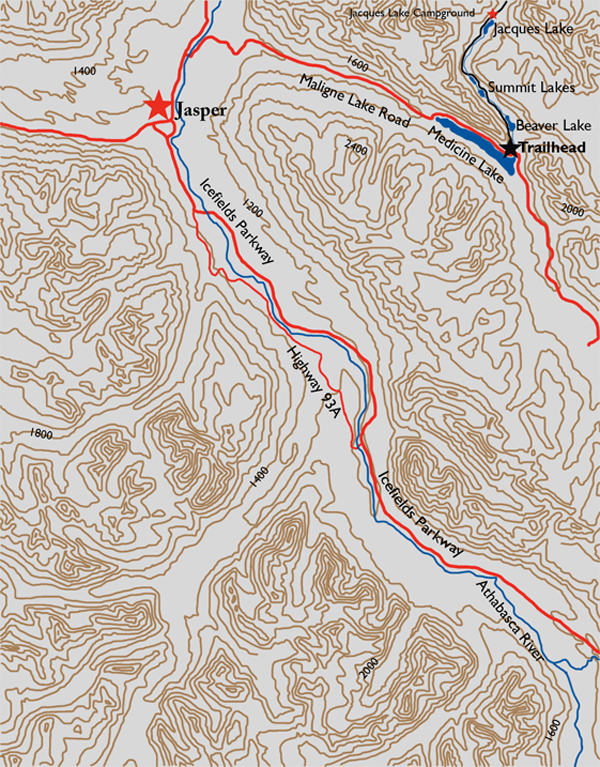
From the traffic lights at the junction of the Icefields Parkway and Highway 16, drive east on Highway 16 for 6 km to the Maligne Lake Road. After crossing the Athabasca River, immediately turn left and drive another 28 km. The pull-off is on the left side, marked as the “South Boundary Trail.”
