Distance
The summit of this day hike is at about the 4 km mark.

Just past the 3 km mark, the road takes a sharp left turn. A secondary road exits to the right – maintain your course on the main road going left. A radio tower stands on the left side, slightly past the apex of this turn.
Carrying on upward, the road enters a huge cutblock a few minutes later and begins to wind its way along the cutblock’s far left (north) edge. After you’ve trudged 10–15 minutes along this boundary, the road plateaus as it reaches the summit of the cutblock.
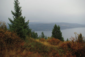
Look for a bike trail sign reading SCHIZO on the right side of the road tacked high up on a topped tree. Although you have already been enjoying the wondrous views, they become richer as you move closer to the edge of the cutblock on the Schizo trail. You are at about the 4 km mark of the hike.
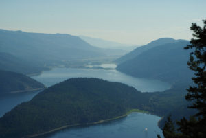
Farther down the trail, the view changes as the exposure to the south opens up more, although it is still somewhat obstructed. To better see the sights to the south, return to the main road and continue to a yellow 4.3 km marker. Take the right-hand fork here. Soon you will see the 5 km marker; continue for another 300 m or so until the forest on the right opens, exposing the valley below toward the south.
Return the same way.
Directions
Driving eastward on the Trans-Canada Highway through Salmon Arm, turn right (south) on Highway 97B. Travel 1.9 km on 97B and turn right onto 10th Ave. SE. Carry on for 1.5 km to the end of the road and a gravel parking lot.