Distance
The park is wilderness and no trails lace the backcountry. Hikers into this region must be experienced in bushwhacking, routefinding and wilderness travel. Exploring the park offers days of good hiking, where you can climb between the lakes on various plateau levels. Twenty lakes sparkle against the talus and numerous mountain peaks separate the sky. Bleak Lake may still hold the remnants of a tiny glacier.
There are no facilities in the park and it is too remote for cell-phone access. Plan on several days of hiking and camping in this park.
Maps
Topographical maps, 1:50,000 series edition 3, featuring 100-ft. contour changes, are adequate for most hikes and most routefinding. St. Mary’s Alpine is too fractured for normal map and compass routefinding. A gentle slope indicated on the map as a potential route is often a series of cliffs. The cliffs may not be big enough to alter the contour lines, but they certainly influence travel. More detailed, black and white, 1:20,000-scale topo maps may be more useful in this wilderness park. They are available from map vendors in Cranbrook. Use 1:20,000 scale 82F.099 and 82F.089.
Park status
Neighbour to Purcell Wilderness Conservancy to the north, St. Mary’s Alpine Provincial Park adds another protected wilderness to the Purcell Mountains. The 9164-ha park lies at the headwaters of the St. Mary River and was set aside as a Class A park in 1973.

With the help of an ATV or a good 4x4 and experienced driving skill, this hike can start almost at tree line.
South access hike route
Manson Col is on the southern boundary of the park, but the access leads into the wilderness area. The route leads to the pass east of Mount Manson. Several lakes within St. Mary’s Alpine are below the pass. The best part of the hike is being at the pass or the scramble up Mount Manson.
From the parking spot, take the left fork road (downhill) for about 1 km toward the forest and a park registration box. Cross a tiny creek and bushwhack straight ahead (northwest), staying at about the same elevation, toward a lush meadow beside the main creek on your left. Follow up the trail by the steepening mountain stream.
At the top of the sloping ramp of a waterfall, cross the creek (usually tiny in midsummer) and above the waterfall wind your way up the creek valley. Cross the creek again and stay to a trail leading to the subalpine.
A small tarn is in the subalpine basin. From the subalpine meadows, routefind up to the rocky boulder pass at 2410 m (7,920 ft.).
West access trail
A trail leaves the parking spot and ascends to the ridge and the park boundary. The trailhead is hard to locate from the landing/parking spot. Alders sprawl over the ground, reducing visibility. The trail heads steeply uphill (east) and may be indistinct as it climbs through the thinning subalpine forest.
Once in the park, there are no trails. Routefind northeast to Mortar Lake and you are on your way.
We spent five glorious autumn days exploring the park between the alpine larch in their golden autumn attire and the stark white granite talus and boulder slopes. We hiked from the west access to Mortar Lake down the creek and around up to Price Lake. From Price Lake we explored to Lyallii Lake and north to Bleak Lake. The climb up to the pass by Mount St. Mary lead us down to the Wesley Creek trail to the north access at the Dewar Creek Hot Springs trailhead. We pre-arranged a car shuttle between the two trailheads.
Before attempting that wilderness route, ask BC Parks if the Wesley Creek trail is still hikable, as it was starting to be overgrown with alders.
In good weather it can be a fabulous trip. In foul weather, the park is a dangerous jumble of cliffs, talus slopes and passes that don’t connect with your intended route. We know hikers who became lost and some had to spend an extra day or two because the route was too slippery with snow and sleet to negotiate. Routefinding in this park is further complicated by sudden snowstorms and white-out conditions (surprisingly very common even in summer).
North access hikes
Wesley Creek is the route/trail into the north by Mount St. Mary and Bleak Lake, but trail details for Wesley Creek are not included in this edition. Head east (right) from the parking.
See Dewar Creek for road directions. Park at the Dewar Creek Hot Spring trailhead (left).
Rating: all the St. Mary’s Alpine hikes are moderate to difficult
Time: long day hikes or several days backpacking
Trail: no trails; rugged landscapes over boulders and alpine
Map: 82F/16 Dewar Creek (NAD27)
Trail map
South access hikes: Manson Col, east of Mount Manson
Distance: 2.5 km
Elevation gain: about 1000 m (3,280 ft.)
Manson Pass: 2410 (7,920 ft.)
Trail: some trail; some routefinding in open alpine and thin forest
Drive: South Access St. Mary’s Alpine Park
Road map: Southern Purcell Mountains and St. Mary’s Provincial Park
Road directions: continued from St. Mary River earlier in this chapter
8 km: Dewar Creek Road.
Road: ATV or very rough high-clearance
Leave Dewar Creek Road (near 8 km sign), N14600-E43500. Turn right, uphill (east) up rough road with large sharp rocks and deep waterbars. Road gains 820 m (2,700 ft.).
1.7 km: Take the left fork.
5.1 km: Road forks in a large subalpine basin. Park off the road. The road gains 700 m (2,300 ft.) of elevation and ends at 1970 m (6,460 ft.).
West access hikes: main access to centre of park, many lakes
Distance: 4 km to park boundary
Elevation gain: about 700 m (2,300 ft.)
Pass at park boundary: 2377 m (7,800 ft.)
Trail: some steep trail; some routefinding in open alpine and subalpine forest; granite talus
Trail map
Drive: west access to St Mary’s Alpine Park
Road map: Southern Purcell Mountains and St. Mary’s Provincial Park
Road directions: continued from St. Mary River earlier in this chapter
15 km: Dewar Creek Road
Road: ATV or very rough 4x4 high-clearance
0 km: Leave Dewar Creek Road at 15 km and turn right (east) uphill, N19900-E39400. Drive the rough road up a series of steep switchbacks on a steep sidehill for 6.5 km. The ATV road gains 425 m (1,400 ft.) to 1700 m (5,600 ft.).
6.5 km: End of the road in a clearing. The trailhead to Mortar and Pestle Lakes is east, uphill. With the help of an ATV or a good 4x4 and experienced driving skill you can trim a lot of elevation by driving the road to the west access trailhead and a wide parking spot with a trailhead registration box.
St. Mary’s Apline Provincial Park holds a tiny glacier on the slopes above Bleak Lake.
Meachen Creek and Perry Creek
Meachen Creek FS Road, continued from St. Mary River earlier in this chapter, St. Mary’s Lake Road at 16 km
Access for hikes:
Meachen Creek Falls
White Boar Lake
Hourglass Lake
Haystack Lake
Maps: 82F9 St. Mary Lake; 82F/8 Grassy Mt.; 82F/7 Boswell (NAD 27)
Road map and also the detailed map of Meachen Creek, Perry Creek and Moyie River roads
Road: most of the road is rough but still suitable for a car at the time of this writing; roads change quickly, and in a year or so you may need a high-clearance vehicle for Hourglass Lake and Haystack Lake; all new bridges 2008
Reset odometer to 0.
Drive
Turn south (left) from St. Mary Lake Road onto signed St. Mary River Road (27 km sign). The turnoff is 500 m before the scenic St. Mary Lake. If you reach the lake you have gone too far.
0 km: Turn off St. Mary’s Lake Road, N95300-E60400, and cross the wooden bridge. (Optional: the first right fork after the bridge leads to a view of the lakeshore that is worth a stop.)
600 m: Take the second right after the bridge, which is a sharp switchback uphill onto St. Mary/Hellroaring Creek Road. There is a faded, obscured sign.
1.6 km: Turn right onto St. Mary/Meachen Road (not signed; also called Meachen Creek Road), N94363-60277. This is the first major road forking to the right from Hellroaring Creek Road (there are two minor right forks).
Reset odometer to 0.
0 km: Junction of St. Mary/Hellroaring Creek Road and Meachen Creek FS Road. For 8 km stay to main road, as there are many new roads branching from it.
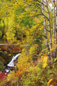
8 km: Meachen Creek Falls; parking along road (8 km sign), N93921-E53141, at 1080 m (3,540 ft.). See #21 Meachen Creek Falls; unsigned trailhead.
8.2 km: Left fork uphill.
15.1 km: Mount Evans Trail/Fiddler Creek Road, not in this edition. Just before the 14 km sign, turn left (south), unsigned, N91488-E47913.
17 km: White Boar Lake (square-post sign); turn left (south); see #22 White Boar Lake, N90068-E46493; at1330 m (4,360 ft.). (If you see the 16 km sign, you have gone too far by about 800 m.) Drive up this rough, rocky, side road for 3 km, gaining 213 m (700 ft.) from Meachen Creek Road to a wide parking spot for lake access.
19.8 km: Take left fork. Meachen Creek FS Road crosses the creek a few times. Stay on the main road.
27 km: Take left fork.
29 km: Hourglass Lake, see #23 Hourglass Lake, N85461-E37497, at 1580 m (5,200 ft.) unsigned trailhead, park in landing along road.
Look high on the right side forested slopes for a thin white streak of a waterfall. The trailhead/parking is the only pullout along this section of road where you can see the waterfall.
30.7 km: For Haystack Lake. Stay on main road at about the same elevation. Take right (lower) fork. Beyond 31 km will require a high-clearance vehicle.
32.3 km: Haystack Lake trail, see #24 Haystack Lake and Upper Haystack Lake, N82578-E36758, at 1737 m (5,700 ft.). Park at the end of the road (unsigned).
Directions

Janice Strong
Janice Strong is an established professional outdoor photographer. Her images grace collections all over the world and appear in many respected publications. She is passionate about hiking and is also an avid snowshoer and skier, exploring the outdoors of the East Kootenay in southeastern BC year round.She openly shares her passion for the outdoors with others and has introduced hundreds of people to the joys of hiking. For a decade she led hikes for the City of Cranbrook – Parks and Recreation. With her guidance, many people have themselves become enthusiastic hikers.
Climbing mountains, finding new places and enjoying the experience of the journey have always been important to Janice. She cherishes the little things she sees along the trail, as well as the grand destinations.
When Janice is not writing, hiking or taking photographs, she is involved in various creative digital, website design or photographic projects for her clients. She and her husband, Jamie Levine, enjoy their rural property, near Cranbrook, BC.