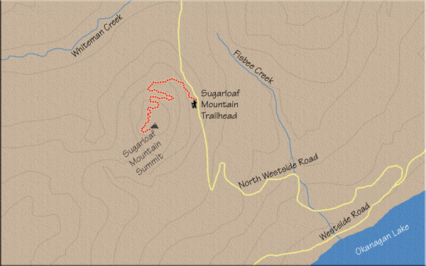
Distance
Within another 300 m or so, you’ll come to another junction. Again a marker will steer you in the correct direction (straight). From here, the trail begins an upward climb, and as you ascend, a third sign sends you to the right. The trail becomes narrow and the grade decreases, even becoming level in spots.
Fifteen minutes into the hike, you will meet up with the trail you departed from at the start of the hike. This is the 1 km mark of the journey, and as you approach it the path plateaus at the crest of a rise. Here you catch the first glimpse of Okanagan Valley beauty, with a wonderful view of Whiteman Creek Valley.
You now come to a small clearing on a broad ledge. The trail resumes beyond some sizable rocks at the far end of this clearing.
Two more signs direct you to your left, this time just a few minutes up the path. Switchbacks become the dominant feature as you challenge your lung capacity for nearly 500 m. There are a couple of reprieves when the trail levels off periodically, but it then switches back and forth for an additional 500 m.
At the 2 km mark, the path flattens and the forest thickens for the final 10-minute strut to the viewpoint.
Be careful – the edge appears abruptly and the drop is sudden and lengthy. As much as this panorama of Okanagan Lake is spectacular, it is even more expansive if you venture a bit farther to the left (south) to the true viewpoint.

Directions
From Vernon, drive north on Highway 97, and at the north end of Swan Lake continue on Highway 97, following the road signs for Kamloops. Travel for 5.6 km, driving past the Spallumcheen golf course and Historic O’Keefe Ranch, and highway signs will direct you down Westside Rd. toward Fintry and Killiney. Drive 23.2 km to North Westside Rd., turning right up this gravel road. You will know you are on the correct gravel road when you spot a large wooden sign saying HIKING TRAIL fastened to a large tree on your left at the start of the gravel road. Carry on upward for 3.75 km, looking for the green and white hiking trail sign on the left side of the road.