Distance
You can either drive up the rough road and hike the very short trail or hike Swansea Slopes trail/routes from the base of the road. There is no water on this hike and the trail may be very hot in summer. However, in the spring and fall many local citizens use it as a training trail.
History
Swansea Mountain held an early 1900s mine for copper, near today’s top parking lot, and the ore was hauled down in rawhide bundles to Athalmer. In 1924 the summit was used for a fire lookout tower. The lookout tower was discontinued and dismantled in 1992. Since the 1970s hang-gliders have been taking to the air from Swansea Mountain.
Trail drive to the top
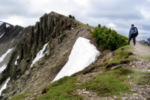
From the upper parking lot, hike the steep short trail for about 20 minutes to the summit. The trail climbs 110 m (360 ft.) in about half a kilometre. At the lookout there are picnic tables and an outhouse.

The trailhead begins on the left side of Mount Swansea FS Road, about 150 m from the Westroc mine offices. I have not tried this trail. It may have variable conditions, but I understand it is popular.
0 km: From the base of the road the trail begins on the left (west). The trail veers away left and ascends the slopes.
4.4 km: The top parking lot for Swansea Mountain lookout, N95300-E74200. For the way down, look for a trail heading off the east side, and descend via the south ridge trail.
10 km: Base of the trail on the main Swansea Road just uphill from where you started.
Mount Swansea
Hikes: Mount Swansea Lookout, Swansea Slopes and the access road for Bumpy Meadows–Pedley Pass
Directions
Windermere Loop Road connects with Highway 93/95 in two places. Both distances are measured from the stoplights on the highway at the turnoff to Invermere.
0 km: Drive south on Highway 93/95 from the stoplights for Invermere.
2.6 km: For north access to Windermere Loop Road, turn left (east), N93509-E71827. Drive the loop road for 3.2 km and turn off left or continue south on the highway to:
6.5 km: South access to Windermere Loop Road (also called Kootenay #3 Road), N90263-E73196. Take the left fork at 1 km. Drive another 3 km and turn off right. The turnoff (east) from Windermere Loop Road, N92467-E74527, is an H shape where two major roads run parallel and the turnoff is the centre of the H.
Reset odometer to 0.
Mount Swansea FS Road
Steep, especially between the 1 and 2 km signs. Switchbacks are groomed with ample parking at the top.
0 km: Turn east from Winderemre Loop Road.
30 m: Cross the Westroc mine haul road. Drive straight on the (signed) Mount Swansea FS road. (For Bumpy Meadows, turn right onto the mine haul road; watch for huge mining trucks Monday to Friday.)
150 m: Lower trailhead for Swansea Slopes trail begins on left.
5 km: Upper parking lot and Mount Swansea trailhead to the lookout. Road ends, N95300-E74200.
Swansea Slopes trails
The trailhead begins on the left side of Mount Swansea FS Road, about 150 m from the Westroc mine offices. I have not tried this trail. It may have variable conditions, but I understand it is popular.
0 km: From the base of the road the trail begins on the left (west). The trail veers away left and ascends the slopes.
4.4 km: The top parking lot for Swansea Mountain lookout, N95300-E74200. For the way down, look for a trail heading off the east side, and descend via the south ridge trail.
10 km: Base of the trail on the main Swansea Road just uphill from where you started.

Janice Strong
Janice Strong is an established professional outdoor photographer. Her images grace collections all over the world and appear in many respected publications. She is passionate about hiking and is also an avid snowshoer and skier, exploring the outdoors of the East Kootenay in southeastern BC year round.She openly shares her passion for the outdoors with others and has introduced hundreds of people to the joys of hiking. For a decade she led hikes for the City of Cranbrook – Parks and Recreation. With her guidance, many people have themselves become enthusiastic hikers.
Climbing mountains, finding new places and enjoying the experience of the journey have always been important to Janice. She cherishes the little things she sees along the trail, as well as the grand destinations.
When Janice is not writing, hiking or taking photographs, she is involved in various creative digital, website design or photographic projects for her clients. She and her husband, Jamie Levine, enjoy their rural property, near Cranbrook, BC.