Distance

Within the first kilometre another bridge crosses the same stream again and remains with you for a great deal of the trek. The route now begins its gradual climb, and from here on in it continues to climb very insidiously, with intermittent plateaus. Even though the stream does not stay close to the trail, it is certainly within earshot, but 30 to 40 minutes into the hike the trail departs the sound of the stream and suddenly the forest is silent. It is a remarkable transformation. You are really not aware of how loud the stream was until it is gone.
Another ten minutes beyond the bridge brings the trail to the first of two short, dilapidated boardwalks crossing a bog. The second one is another 40 minutes away and contains two galvanized drain pipes. From here, there is only another 20 to 25 minutes of backpacking to go. Taylor Creek is crossed for a third time just prior to rising to the open, flat, mushy meadow of Taylor Lake. Crossing this soggy meadow requires some skilled manoeuvring to remain dry. Follow the sign to Campground Ta6.
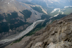
The campground sits level on the shore of the lake, containing a bear pole and an outhouse. It is a place of silence and splendour. Having mountain peaks looming on both sides and an opening between them at the far end, the lake is iridescent yet clear, with many surrounding features available to reflect in it. Even the outlet area is still and clear.
For day adventures, return to the main trail to find the sign that directs the trail toward O’Brien and Boom lakes. The trail to these lakes is lined with forest, with a couple of small wildflower meadows. The much smaller O’Brien Lake is encountered first, at 2.1 km from Taylor Lake, while Boom Lake is much farther, at 7.5 km. If Boom Lake is on your list, it would be a much quicker trip from its own trailhead on the Banff-Windermere Highway (Highway 93 south). The distance in is only 5.1 km.
History
Taylor Lake draws its name from George Herbert Taylor, who worked as a packer for A.O. Wheeler during Wheeler’s employ with the Dominion Topographic Survey. It is unknown who named the lake or when.
The name of nearby O’Brien Lake does not have a definitive origin, thought it is thought the lake may have been named after a particular CPR section supervisor.
Directions
Drive west from Castle Junction for 8.2 km or east from Lake Louise for 20 km to the Taylor Lake parking lot on the south side of the Trans-Canada Highway.