Distance

Continue for an additional 20–30 minutes until you reach a fork in the trail. A trail sign at this point marks the Tonquin Valley Trail to the right, while the left fork crosses the Astoria River and goes to Chrome Lake, Outpost Lake and the Emerite Valley. The left route will take you to Amethyst Lakes via the Wates-Gibson Hut, but it’s a significantly longer choice. The main trail makes its way through a horse gate and corral to resume the Tonquin Valley Trail. Within 10–15 minutes from the horse gate is a massive avalanche slope of resistive quartzite. Notice the jagged edges of this stone, as opposed to the smoother edges of limestone avalanche rock. These edges remain so sharp because resistive quartzite, unlike other rock, is not weathered away by rain, snow or wind, but only by frost heaves.
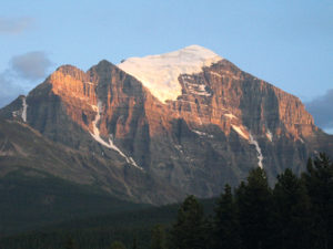
After passing below this massive slope the trail begins the arduous yet inspiring upward climb of switchbacks that come in and out of the forest as they run upward alongside the avalanche slope. The switchback section rises to 2194 m (about 400 m elevation gain). Roughly an hour later the trail levels off, opening up to low-growth trees and exposing an amazing view of the Ramparts. The Ramparts are a series of peaks at the headwaters of the Fraser River, with Parapet Peak on the south end of the ridge as the highest point. These stunning, unmistakable landmarks tower over the western shore of Amethyst Lakes, creating one of the most startling backdrops in the Rocky Mountains. The British Columbia/Alberta boundary runs the length of the Ramparts, bisecting them down the middle.
The upper valley trail consists of long, undulating hills which are remarkably fun to hike. The stunning scenery up in this openness makes the climb up the switchbacks easily forgettable. Along the upper trail, kilometre 12.9 marks the junction to Switchbacks Campground, while 3.5 km later (16.4 km total) you will intersect the junction to Clitheroe and Surprise Point campgrounds. From here you will descend back into the forest as the trail takes you downhill to Amethyst Lakes Campground.
History
This valley hike is full of history that did not occur here. The name “Tonquin” was assigned by the Geographic Board of Canada to pay homage to the ship of the same name, which was commissioned by John Jacob Astor in 1810 to establish a permanent trading post at the mouth of the Columbia River. During a trading mission on Vancouver Island, the crew of the Tonquin were killed by Indians agitated by the insulting behaviour of the ship’s captain, Jonathan Thorn. The Astoria River is named after John Jacob Astor, while Franchère Peak, in this vicinity, is derived from one of the only few survivors of the massacre.
The Tonquin Amethyst Lakes Lodge was constructed on the shores of Amethyst Lake (actually two connected lakes) by Fred Brewster in 1939 and is still in operation today. Along with the campground and a Parks cabin, the lodge is the central charm on the shores of the Amethyst Lakes. The lodge, campground and Parks cabin are located at the narrows joining the two lakes, while another lodge is settled at the north lake.
On one of my last trips into the valley, in 2006, I was fortunate enough to encounter a hiker coming out of the Tonquin Amethyst Lakes Lodge where he had just enjoyed the weekend. With this elderly gentleman hiker were his daughter and son-in-law and their young children. As luck would have it, he stopped for a breather at the same spot where we were resting. He was alone at first, in the lead, with the rest of the family having trouble keeping up with his pace. He was 70 years old, and the weekend had been to celebrate the 50th anniversary of his time as a youth working at the lodge. He had worked summers packing food in to the lodge, fetching water and cutting firewood, and in his spare time he climbed the surrounding mountains. The one thing that still sticks in my mind is that he said that nothing had changed except that the trees had grown taller. Other than that, the lodge, lake, mountains and streams were just as he had left them 50 years before.
Directions
Travelling south from Jasper on the Icefields Parkway, turn right onto Highway 93A. Take Highway 93A south for 5.2 km until you reach the Edith Cavell Road. Climb the Edith Cavell for 12.5 km and park at the Tonquin Valley Trailhead.