Distance
A day hike to Wall Lake is a good opportunity to initiate beginner hikers, as the wide and gentle grades on this trail are well-used and -signed. For experienced hikers the scenic shores of Wall Lake is only the beginning of the hike to Akamina Ridge.

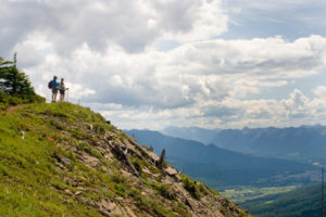
To extend the day hike, combine Wall Lake with Akamina Ridge. It’s the most spectacular ridge walk I know of. The ridge traverses the wide alpine meadow ridge atop the cliffs rising from Wall, Forum and Cameron lakes.
Rating: easy hike or mountain bike
Time: short half-day hike
Distance: 5 km from parking on Cameron Lake Road
Elevation change: 150 m (500 ft.)
Wall Lake: 1798 m (5,900 ft.)
Trail: good BC Parks trails, signed and graded; good packed surface for mountain bikes
Map: 82G/1 Sage Creek (NAD83)
Trail map
Drive
Road: any vehicle; all pavement
Access to this BC Park is most often from Waterton Lakes National Park in Alberta. Drive Alberta Highway 6 south of Pincher Creek for 48 km into Waterton Lakes National Park.
0 km: Waterton Lakes National Park entrance on Alberta Highway 6.
7.7 km: Turn right (west) onto Cameron Lake Road and drive on a narrow paved road for 14 km.
21.7 km: Park at the signed Akamina Pass pullout.
Trail to Wall Lake
0 km: From parking spot on Cameron Lake Road in Waterton, hike west up Old Akamina Road, gaining 120 m (400 ft.). You could ride a mountian bike to Wall Lake.
1.2 km: Akamina Pass, on the BC/Alberta provincial boundary. For Wall Lake, keep following the wide trail heading west.
1.5 km: Continue straight for Wall Lake. The BC Parks Akamina Campsite is alongside the trail about 500 m west of the pass. (Forum Lake trail branches left.)
3.0 km approx.: Along Old Akamina Road, the well-marked Wall Lake trail branches left (south), meandering over gentle fluctuations of the topography.
5 km: Wall Lake (3.5 km from Akamina campsite).
Forum Lake
Rating: moderate
Time: short hike
Distance: 5 km from parking on Cameron Lake Road
Elevation change: 335 m (1,100 ft.)
Forum Lake: 2000 m (6,560 ft.)
Forum Lake is not as scenic as Wall Lake, as it lacks the deep azure blue. This small lake also shares the big wall of Akamina Ridge, but not as dramatically steep. It is also much shallower with muddy banks.
0 km: From a parking spot on Cameron Lake Road in Waterton, hike west up Old Akamina Road, gaining 120 m (400 ft.).
1.2 km: Akamina Pass on the BC/Alberta provincial border. Keep following the wide trail heading west.
1.5 km: Take left fork for Forum Lake and the (signed) provincial park ranger station. (Forum Falls is behind the ranger station, about 200 m west.) Climb south from the ranger station on a trail in the forest. Trail steepens significantly up through the thick forest.
3.5 km: Forum Lake.
Directions
Road: any vehicle; all pavement
Access to this BC Park is most often from Waterton Lakes National Park in Alberta. Drive Alberta Highway 6 south of Pincher Creek for 48 km into Waterton Lakes National Park.
0 km: Waterton Lakes National Park entrance on Alberta Highway 6.
7.7 km: Turn right (west) onto Cameron Lake Road and drive on a narrow paved road for 14 km.
21.7 km: Park at the signed Akamina Pass pullout.

Janice Strong
Janice Strong is an established professional outdoor photographer. Her images grace collections all over the world and appear in many respected publications. She is passionate about hiking and is also an avid snowshoer and skier, exploring the outdoors of the East Kootenay in southeastern BC year round.She openly shares her passion for the outdoors with others and has introduced hundreds of people to the joys of hiking. For a decade she led hikes for the City of Cranbrook – Parks and Recreation. With her guidance, many people have themselves become enthusiastic hikers.
Climbing mountains, finding new places and enjoying the experience of the journey have always been important to Janice. She cherishes the little things she sees along the trail, as well as the grand destinations.
When Janice is not writing, hiking or taking photographs, she is involved in various creative digital, website design or photographic projects for her clients. She and her husband, Jamie Levine, enjoy their rural property, near Cranbrook, BC.