
Distance
These reflective and tiny blue/green lakes are awe-inspiring under a land of stark white rock that teeters over much of the austere landscape. North Star, Carmarthen and Centaurus glaciers crack and grind away the highest regions around the lakes. The spiked summits of Welsh and Irish peaks rise in stepped cliff bands to over 2890 m (9,500 ft.), ringing three sides of the Welsh Lakes basin.
The hike is a rewarding high-country exploration.
Suddenly from the ridgetop we heard a gigantic “crack!” A large boulder sheared from the flanks of Irish Peak. The rock smashed into another boulder and the two hurtled downhill. They slammed the talus hillside and started a thundering landslide. We watched with excitement as the rocks crashed from the ridgetop, careened down the slope and in a dramatic finale splashed into the lake.
Then the mountains fell silent, except for our animated chatter. No sooner had our voices settled when another rock fell from the peaks. Frequent bursts of mountain energy catapulted truck-sized boulders down the slopes. We watched as the Purcell Mountains eroded.
Mountains are truly dynamic places. Although the rocks were falling across the lake and we were safe from their destruction, the rock slides were still unnerving.
Welsh Lakes is also a land of extremes; blizzard conditions are common, even during summer. The sky was overcast when we crawled into our tents, and chilled air hung in the lofty basins. The next morning we awoke to a July snowstorm and 15 cm (6 in.) of wet snow.

Upper Welsh Lake
I think this lake is the finest of the Welsh Lakes group. It is a 1-km bushwhacking route, gaining another 45 m (150 ft.). This oval lake 500 m in diameter is more scenic than Lower Welsh Lake. Its blue-grey water creates perfect mirror reflections as the lake disperses chalky glacial silts. Large angular rock slabs extend into the icy water. The Irish and Welsh peaks stand high above and extensive boulder slopes stretch for more than a kilometre to the south to Centaurus Glacier.
Pass between Centaurus Glacier and Killarney Peak
From Upper Welsh Lake hike south over the loose jumble of boulders up to the pass at 2650 m (8,700 ft.) There is no trail. Views of the distant Farnham Tower and an expanse of rock with blue ice and no plants.
Aberystwyth Lake
From Lower Welsh Lake climb west up 152 m (500 ft.) on talus and steeply forested slopes. Again, there is no trail. Aberystwyth is a small, half-kilometre-wide, green-grey lake, with the entire southern view being stark white boulders. Carmarthen and Glamorgan peaks dominate the scene.
Fourth Welsh Lake
This tiny unnamed alpine lake can be reached by hiking southwest up 210 m (700 ft.) from Upper Welsh Lake. It lies in a rock basin at 2435 m (8,000 ft.) elevation. Trail
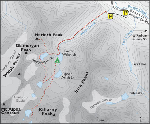
0 km: Upper parking lot, N10347-E37896. The footbridge is out, so cross to the southwest side of tiny Welsh Creek by stepping on well-placed boulders. Stay on the northwest side of the creek for the entire hike. Follow the remains of the road, now overgrown with alders, parallel to the creek.
1 km: The path heads over some bedrock outcroppings. Pay attention to a few confusing sections. The creek flows into a smooth shallow pond on your left.
2.2 km: The trail leaves the forest and approaches a talus slope. Cairns mark the way.
2.6 km: Climb up the rock trail. The creek splashes in a deep canyon on your left. The final 1.5 km is very steep as it zigzags up a forested rocky ridge.
4.3 km: Trail ends at the north end of the Lower Welsh Lake, N08435-E35744, at 2180 m (7,150 ft.).
4.5 km: Best campsite is on the shore of a scenic bay about halfway along the west side of the lake, N08206-E35688.
Lower Welsh Lakes, with turquoise water.
#12 Thunderwater Lake – Whirlpool Lake
The name Thunderwater conjures up images not just of water but of churning, splashing, falling water. This hike features an abundance of moving water, frozen water, scenic tumbling cascades, icy creek crossings and damp meadows. Fording creeks is typical of remote alpine hiking, but this hike crosses glacial creeks with fast current and fluctuating, melting-ice runoff.
Thunderwater Lake is an amazing, high-elevation, turquoise, alpine lake stretching out in a 2-km-long, glacier-hewn, oval valley at the headwaters of Forster Creek. Thunderwater and Whirlpool lakes both tuck below the flanks of Catamount Glacier.
Thunderwater Lake is the largest lake in the vicinity, and along its northern shore sparkling springs trickle between grassy mounds, where brightly coloured wildflowers spread over the moist slopes. The landscape is vibrant with colour for just a couple of weeks in early August.
Only 60 m (200 ft.) higher than Thunderwater Lake hides indigo-coloured Whirlpool Lake. Larch trees and slopes of wildflowers are sparse along its bleak shores. Granite rock rims the slopes, where snow and ice still dominate from the last ice age. Whirlpool Lake is nonetheless beautiful in its own way.
Rising in smooth folds south of these two spectacular lakes is Catamount Glacier. The wrinkled ice surrounds all but the tops of the high summits: Mount Harmon, 2895 m (9,500 ft.), and Mount Griffith, 2740 m (9,000 ft.).
For mountaineers and glacier travellers, there is a public-use shelter, Olive Hut, high up on the slope by Catamount Glacier. To reserve space in the hut contact the Columbia Valley Hut Society (Contact Information and References). The trail to the hut leaves the Thunderwater trail at 2.8 km from the trailhead, at the base of a white granite moraine, N11732-E32482.
Further explorations
Whirlpool Lake
Hike 1.8 km west along the north shore of Thunderwater Lake on open rocky slopes gaining minimal elevation to the austere, turquoise, glacier-meltwater lake.
Dave White Hut is a winter-only hut for skiers, managed by the Columbia Valley Hut Society (Contact Informatio and References). The hut is tucked into the northern slopes of Forster Creek about halfway to Thunderwater Lake.
Edouard Lake at the headwaters of Edouard Creek
This is an advanced hiking route. Edouard Lake, N08315-E27518, at 2070 m (6,800 ft.), is 4 km, or about three hours, from Taurus Notch. Climb from Whirlpool Lake west to the pass at Taurus Notch. Head left (south) along a bench. At the south end of the pass, drop off slightly to the right, aiming for red shale. Work along gradually between heather, sedge and boulders. Do not head toward the big boulder field. It is very unstable, slow going and you still need to lose elevation.
At the next bench, climb a bit higher to a promontory at the same elevation as Edouard Lake. Hike on the steep grass down toward the middle of the valley and follow the easy grade along the creek. Hike up a steep moraine through trees. Almost at the top of the trees, cross over the top of boulder slope. Cross the creek and hike up the right side of the draw, finding a good game trail to the lake.
Directions
Road: 2WD; last 1.5 km 4x4 high-clearance
See also Forster Creek, Horsethief Creek earlier in this chapter for details of roads to Horsethief Creek and Forster Creek from Radium, and from there to Welsh Lakes road directions for Forster Creek FS roads. From the four-way junction of Westside Road and Horsethief Creek Road, drive 33.4 km to the end of Forster Creek FS Road (42 km sign), at 1670 m (5,500 ft.), N11630-E34851 (6 km beyond the Welsh Lakes turnoff, found under #11 Welsh Lakes).

Janice Strong
Janice Strong is an established professional outdoor photographer. Her images grace collections all over the world and appear in many respected publications. She is passionate about hiking and is also an avid snowshoer and skier, exploring the outdoors of the East Kootenay in southeastern BC year round.She openly shares her passion for the outdoors with others and has introduced hundreds of people to the joys of hiking. For a decade she led hikes for the City of Cranbrook – Parks and Recreation. With her guidance, many people have themselves become enthusiastic hikers.
Climbing mountains, finding new places and enjoying the experience of the journey have always been important to Janice. She cherishes the little things she sees along the trail, as well as the grand destinations.
When Janice is not writing, hiking or taking photographs, she is involved in various creative digital, website design or photographic projects for her clients. She and her husband, Jamie Levine, enjoy their rural property, near Cranbrook, BC.


