Distance

The trail to the right travels through undulating forest with such high, steep banks that you should be extra cautious. Falling from these heights could be fatal. The route rolls through the forest of hemlock and spruce for 1.5 km and then suddenly drops to join once more with the wide, flat delta at 8.2 km. You’ll cross some interesting channels down here over sturdy, permanent aluminum bridges. Some 10 to 15 minutes of wandering the flats takes you to the 9-km mark, at the base of a series of switchbacks. The alluvial plain is unique enough to deserve some extra time. The scenery is enormous, as there is nothing to block your view of peaks, waterfalls, limestone walls and green forest.
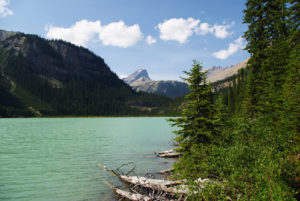
You gain 154 m over the next magnificent kilometre. The beauty of Kinney Lake with the backdrop of Campion Mountain makes the climb barely noticeable. The mountainside ascent reaches its zenith after this gain, then re-enters the trees and begins to ramble up and down. At 10.9 km, a wooden suspension bridge crosses the Robson River to Whitehorn Campground.
This spot is a common base for progressing up the endless switchbacks to Berg Lake. Many day trippers camp at Whitehorn and continue upward for a full day the following day. Reaching the next campground, at Emperor Falls 5 km away, will take 531 m of gruelling elevation gain. Then the trail levels off almost completely for another 5 km to attain Berg Lake Campground. However, the prizes – Berg Lake, Mount Robson, the moraines and glaciers – can be seen clearly from Marmot Campground, 8 km from Whitehorn.
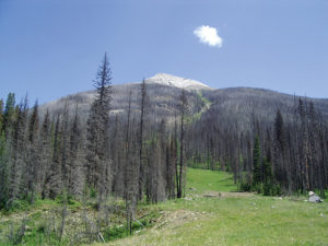
This is indeed a full day, but the beauty is incomparable. The valley beyond Whitehorn is called the Valley of a Thousand Falls. Although a thousand may be a stretch, there is nothing else like this in the Rocky Mountain parks, and possibly on earth. I have taken this trip well over 20 times simply because of the unique diversity and immeasurable magnificence. I have sat in Berg Lake Campground on a clear day, my back against a tree, just gazing at Berg Lake and Mount Robson for hours.
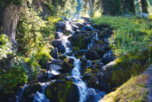
Lurking around Whitehorn Campground is certainly a fascinating day, with trips down to the far north end along the flat, wide banks of the Robson River. Venturing back to the suspension bridge and over to the rocky banks in front of the warden cabin reveals cold pools alive with surging springs, most likely caused by the pressure of the raging river.
Robson history
Arthur Coleman named the exquisitely beautiful Kinney Lake in 1907. As he put it in his book The Canadian Rockies:
Through the bush along the river our loads were an immense nuisance, but presently we reached the forks, and then had good going on the shore of a beautiful lake, which had been visited by Mr. Kinney the day before, and has been named Lake Kinney in honour of our indefatigable comrade.
The stunning beauty of Kinney Lake and the entire Mount Robson area were a secondary discovery to the original pursuit of summiting Mount Robson. Still, Kinney Lake, Whitehorn, Valley of a Thousand Falls, Toboggan Falls, Snowbird Pass and Berg and Hargreaves lakes were all magnificent finds by themselves.
Arthur Philemon Coleman, a professor of geology from the University of Toronto, his brother, L. Quincy Coleman, a rancher from Morley, Alberta, and L.B. Stewart, also a professor from the University of Toronto, all set out in the summer of 1893 to find and climb the tallest mountains in North America. For 66 years there had been a legend floating around that mounts Hooker and Brown, in the Athabasca Pass region, reached heights of between 15,000 and 17,000 feet above sea level. After discovering that those peaks were not even close to such a height (Mount Brown is a mere 9,184 feet, while Mount Hooker is slightly taller at 10,781 feet), the Coleman brothers headed for what is now known as Mount Robson in an attempt to hunt down a first ascent of history-making height. In 1907, they departed Lake Louise in search of this legendary peak, and this time, unlike with mounts Brown and Hooker, they would not be disappointed. The reports of a mountain of over 10,000 feet high proved to be underestimated, as Mount Robson rises to 12,973 feet.
A.O. Wheeler had prompted the Colemans to make the journey and arranged to have Reverend George Kinney, a clergyman and mountaineering guide, enlist with the group. The trek from Lake Louise took 39 days, leaving them with supplies for only one attempt, which ultimately failed. It was during this attempt that they came upon Kinney Lake, camping by its shore and using it as a base for this first attempt on Robson. Returning the following year, the same party left from Edmonton, this time with the addition of guide John Yates. During the journey, A.P. Coleman sprained his knee, temporarily suspending his climbing skills.
The following June, Kinney set off alone, once again from Edmonton, “… hoping to pick up someone on the trail to share fortune with me.” While in Jasper waiting for the Athabasca River’s swollen waters to subside, he met Donald “Curly” Phillips, a member of the Guide Association of Ontario. Phillips had come to Jasper to start an outfitting business, but was now on his way to ascending the most elusive summit in the Canadian Rockies. On Friday, August 13, 1909, after enduring hard travel, bad weather and dwindling supplies, they finally summited Mount Robson.
The accomplishment, however, was tarnished with controversy and doubt, and without witnesses or convincing, definitive evidence, their claim of first ascent was disputed and finally disallowed. The summit was officially bagged on July 31, 1913, by an ACC-sanctioned climb. The victorious members of that party were Albert McCarthy, Billy Foster and Conrad Kain. A.P. Coleman was a support member of the ACC base camp alongside A.O. Wheeler, Charles Fay and A.L. Mumm.
Directions
The Mount Robson Visitor Centre is 35 km east of Valemount, BC, and 85 km west of Jasper, Alberta, on Hwy. 16. The village of Valemount is situated along Hwy. 5, 20 km south of the Hwy. 16/Hwy. 5 junction. Turn right and head west at the crossroad to complete the remaining 15 km. The trailhead is 2 km north from the visitor centre, at the end of Kinney Lake Road.

Gerry Shea
“Gerry Shea moved to Kamloops from Vancouver at the age of nine, which is when he became enchanted by the nearby hills. It was on a family vacation many years later that he discovered the mountains and began hiking and climbing in his spare time, gathering knowledge and experience that he has since used to help beginning hikers, scramblers and backpackers to trek safely. Gerry lives in Kamloops with his wife and children.”Excerpt From: Gerry Shea. “The Aspiring Hiker’s Guide 2: Mountain Treks in British Columbia.” iBooks.