Distance
The Mount Broadwood Heritage Conservation Area/Wigwam Flats is a great mountain biking area or an easy place to walk on reasonably level terrain. Many kilometres of roads lace the low hills across Wigwam Flats. The ride is located on a plateau above the confluence of the ruggedly sculpted canyons of the Wigwam River and the Elk River. Mount Broadwood, 2440 m (8,000 ft.), rises in a massive rocky dome to the northeast.
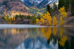
Across the Wigwam River canyon there is an erosion-formed slide-wall of multicoloured rocks and scree in muted tints of beige, peach, purple and rust, which some call the China Wall. Tentative hoodoos stand in fragile pinnacles beside the river. In June white saskatoon bushes are in full bloom along the canyon rim. In summer, the hot sun is intense on these arid lowland flats. In September the cottonwood and aspen trees brighten the countryside with a cheerful vibrant yellow. The Elko Sawmill is loud on weekdays, so you may wish to plan a weekend hike.
Stay to the established trails to avoid crushing the prairie grasses. Wildlife depend on these healthy grasses for their survival.
Cyclists can enjoy the area year round, but motorized vehicles share the roadways during summer only.
The hike at Wigwam Flats–Mount Broadwood is in a wildlife management access area and the roads are closed most of the year except for limited openings in summer. Please obey the signage (see the introduction for more on wildlife management access areas).
Further explorations
Silver Spring rim overlook trail
A trail hugs the cliff edges above the Silver Spring Lakes.
Silver Spring Lakes
The three, clear, scenic and deep Silver Spring Lakes lie just north of Wigwam Flats, in the shadow of Mount Broadwood.
Sheep Mountain
Sheep Mountain, an old forestry lookout across the Elk River, offers a panoramic view of the Wigwam Flats–Mount Broadwood area and the Elk and Wigwam rivers.
Rating: easy mountain biking/easy hiking
Time: day bike ride or hike
Distance: 6.9 km to viewpoint at confluence; 8.5 km to canyon rim above Wigwam River
Elevation gain: 128 m (420 ft.), several ascents and descents
Wigwam River Canyon Rim: 1000 m (3,280 ft.)
High point: 1070 m (3,500 ft.)
Trail: open roads, gentle hills; sections of loose rock; ride on plateau above Elk and Wigwam river canyons
Maps: 82G/6 Elko; 82G/6 Flathead Ridge; 82G/3 Lake Koocanusa (NAD27)

0 km: Park by the Elk River 880 m (2,900 ft.) and ride south, uphill, on a small rocky road parallel to the Elk River canyon and above the Elk River Dam. The first 1.5 km climbs 120 m (400 ft.). The road levels off after a short while, followed by short sections of gentle up and down grades. Stay on the main roads to protect the important grasslands.
2.3 km: Stay on the main road. A smaller track/old road uphill left is the turnoff for Silver Spring rim overlook .
5 km: The main road forks, N57956-E39159, at 914 m (3,000 ft.). Both roads provide good cycling potential.
Wigwam Flats
The left fork at 5 km along the trail climbs up to the level prairie of Wigwam Flats above the Wigwam River canyon. Ride all the way to the eastern edge of the flats and connect to Lodgepole FS Road. Nice flat roads with scenic views of the pale-blue Wigwam River, hoodoos and the multi-coloured erosion wall.
Confluence of Elk and Wigwam rivers
The right fork at 5 km along the trail continues south for another 1.9 km along level terrain to a scenic forested viewpoint above the confluence of two rivers. A footpath leads downhill to the riverbank. River waters can change suddenly, as there is a BC Hydro dam just 4 km upstream and they open the spillways now and then. Up on the plateaus and canyon rims hikers and cyclists do not need to care about the water levels in the deep canyons.
On the way to the confluence viewpoint, cycle by an old homestead. The house is gone, but an abandoned apple and pear orchard remains. A dry reservoir, a root cellar and assorted metal hold only memories of this now forsaken residence. When I walk around an abandoned homestead such as this, I always wonder why the people left. What was their life like on the isolated but scenic edge of the Elk River so many years ago?
Directions
Road: any vehicle; mostly pavement
Forty minutes from Cranbrook, 30 minutes from Fernie.
0 km: Turn east from Highway 3 in to Elko, N62200-E37100. The Elko townsite is not visible from the highway. The turnoff is south (slightly downhill) from the prominent gas station/restaurant along Highway 3. The paved Bate Avenue in Elko winds through town around several corners. Stick to the main road.
1.1 km: Turn sharp left (east) and head downhill 400 m to cross the Elk River.
1.2 km: Park after the bridge, in a wide pullout by the river, N62048-E37746.

Janice Strong
Janice Strong is an established professional outdoor photographer. Her images grace collections all over the world and appear in many respected publications. She is passionate about hiking and is also an avid snowshoer and skier, exploring the outdoors of the East Kootenay in southeastern BC year round.She openly shares her passion for the outdoors with others and has introduced hundreds of people to the joys of hiking. For a decade she led hikes for the City of Cranbrook – Parks and Recreation. With her guidance, many people have themselves become enthusiastic hikers.
Climbing mountains, finding new places and enjoying the experience of the journey have always been important to Janice. She cherishes the little things she sees along the trail, as well as the grand destinations.
When Janice is not writing, hiking or taking photographs, she is involved in various creative digital, website design or photographic projects for her clients. She and her husband, Jamie Levine, enjoy their rural property, near Cranbrook, BC.