Distance
Each of these small lakes, sparkling with reflections of the snowcapped summits above, has distinct colours of sapphire, cat’s eye green or royal blue.
In May or early June the woods are graced with many species of wildflowers in bloom. Springtime also is the busiest for the birds, when they fill the forest with joyful song. Ducks, loons and shorebirds also nest in the area, and Turtle Lake wouldn’t be right if didn’t have all those turtles.
Turtle Lake is small, emerald-green and shallow. A fallen log makes an ideal place for turtles to bask in the sunshine. When approaching the lake, be quiet and avoid sudden movements; try not to frighten the timid, sunbathing turtles. If you wait long enough the turtles may ignore you and will clumsily swim around. Turtle Lake is bordered by a gentle grassy slope between the ponderosa pines and is an ideal spot to enjoy the quiet setting.
Canuck Lake is a deep, royal-blue lake with pine and fir forests hugging its shores. The Rocky Mountains rise in an even slope to the summits high above the lakeside.
Yankee Lake is dark blue and Y-shaped, at the base of the Rocky Mountains. This is the nicest lake of the three. At the northern edge of the lake, the trail forks. The right fork is the main trail, but for a nice detour take the left fork around some blowdowns on a trail to reach the joint of the Y. There you will find a rocky beach with water on two sides. It looks like tropical white rock with aquamarine water splashing the gradually sloping shore. This is the spot for your picnic!
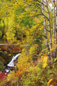
The trail between the lakes climbs and descends several times through a forest of Douglas fir, ponderosa pine, western larch and lodgepole pine.

Hiking the loop takes about three to four hours, including stops.
0 km: In Premier Lake Provincial Park, begin the hike from the first campground, east side of the road, at 884 m (2,900 ft.). Follow the mossy trail northeast. Cross Staples Creek bridge. The trail climbs steeply for the first 500 m, gains 70 m (200 ft.).
300 m: Cat’s Eye Lake trail branches right (south). The hike to Cat’s Eye Lake is a detour from the main loop. Climb steeply (south) for 1 km on a wide road. The tiny and shallow Cat’s Eye Lake is the colour of green cat’s eyes. Return to the main trail to continue the hike.
500 m: On the main trail, turn left (north) at the Turtle Lake junction. Go either to Turtle Lake or continue straight to Yankee Lake. I prefer to go to Turtle Lake first. Hike the good trail through the forest with views of Premier Lake below you.
1.8 km: Turtle Lake. Stay on the main trail heading north. Gain elevation to 990 m (3,429 ft.) at the highest spot on the hike, N31439-E98513.
3.7 km: Canuck Lake. Near the shore, a switchback trail (left) branches from the main trail for 100 m or so to a nice spot along the lakeside.
4.3 km: Trail junction at Yankee Lake northern edge. Right fork is the main trail along western lakeshore. (Left fork is an overgrown trail to white rock “beach,” about a 300-m detour, but worth it. Backtrack to the main trail.) The western lakeshore (main trail) also has other nice rocky beaches.
4.9 km: Reach the outlet of the lake at a tiny creek. Follow the trail up a bit and then descend back to the parking lot. This outlet creek is the trailhead to the much harder trip up to the ridge of the Rockies, Saddleback Trail,
6.3 km: Junction with Turtle Lake trail.
6.8 km: Parking lot.
Further exploration
Saddleback Trail
Saddleback Trail is for fit hikers who enjoy a rugged long climb to a ridge of the Rocky Mountains. In some years this trail is cut free of blowdowns; in other years the lower part is a tangle of wind-tossed trees. The trail winds around the valley bottom somewhat, then an arduous climb begins. The climb to the Saddleback Ridge and back to the vehicle is a long, strenuous, day hike.
Directions
Road: any vehicle; good gravel and pavement
0 km: From Highway 93/95, turn east at the signed road for Premier Lake Provincial Park, 1 km north of Skookumchuck and the bridge over the Kootenay River. (If driving the highway from the south, stay right at 0.8 km. The left fork just connects back to the highway.)
6.7 km: Turn right (south) on Premier Lake Provincial Park Road (the left fork is Wasa Sheep Creek Road).
11.7 km: Follow the signs to the provincial park campground.
13.7 km: Turn left.
14.1 km: Park at the day-use site by the first campground. A sign marks the trailhead for Yankee and Canuck lakes.

Janice Strong
Janice Strong is an established professional outdoor photographer. Her images grace collections all over the world and appear in many respected publications. She is passionate about hiking and is also an avid snowshoer and skier, exploring the outdoors of the East Kootenay in southeastern BC year round.She openly shares her passion for the outdoors with others and has introduced hundreds of people to the joys of hiking. For a decade she led hikes for the City of Cranbrook – Parks and Recreation. With her guidance, many people have themselves become enthusiastic hikers.
Climbing mountains, finding new places and enjoying the experience of the journey have always been important to Janice. She cherishes the little things she sees along the trail, as well as the grand destinations.
When Janice is not writing, hiking or taking photographs, she is involved in various creative digital, website design or photographic projects for her clients. She and her husband, Jamie Levine, enjoy their rural property, near Cranbrook, BC.